An underwater sonar mapping project by archaeologists in Italy has determined that the bottom of the Venetian Lagoon was once dry land. The team of researchers have confirmed that an ancient Roman road and settlement once thrived in the area some 500 years before Venice was founded in the 5th century.
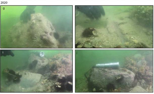
In the 1980s, surveys of the Treporti Channel in the northern part of Venice‘s outer lagoon identified what ‘looked like’ a submerged Roman road with structures aligned along its course. Recent archaeological dives revealed stones with a smooth upper face and ovoid undersides that were similar to “Roman basoli.” Now, it has been confirmed that an ancient Roman road was indeed submerged in the Venice Lagoon, and it was lined with “extensive settlements.”

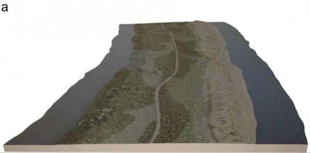
Left) the reconstruction of the Roman Road in the Treporti Channel in the Venice Lagoon made on the basis of the multibeam data. Credit: Antonio Calandriello and Giuseppe D’Acunto. Right) the same area now submerged. (Fantina Madricardo / Nature)
Professor Fantina Madricardo is a geophysicist with the Institute of Marine Science (ISMAR) in Venice, and last week she published her new study in the journal Scientific Reports about the recent sonar explorations of lagoon islands and waterways. Hoards of artifacts were discovered suggesting human occupation and even evidence of a structure that is suspected to be an ancient harbor, or dock.

An array of stones matching the types used in Roman road construction have been located by divers. (Madricardo et al./ Nature)
Sizing Up The Lost Settlement
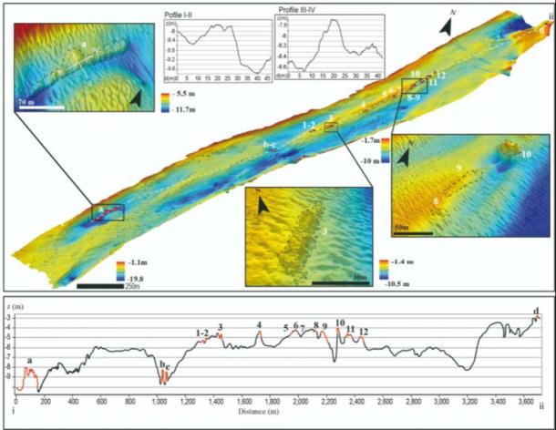
These new investigations of the suspected ancient route were delayed by extensive industrial developments around the lagoon. But now, “12 archaeological structures” have been identified on a northeasterly alignment extending “1,140 meters” in an area of the lagoon known as the Treporti Channel,” according to the study.
The new discoveries at the bottom of the Treporti channel determine the structure was indeed a Roman road and the foundations clinging to its sides measure 2.7 meters (9 ft) tall by 52.7 meters (173 ft) long. Four additional structures measured four meters (13 ft) tall and 134.8 meters (442 ft) long which are thought to represent a harbor, or dock.

High resolution bathymetry of the Treporti Channel (The numbers 1 to 12 indicate the alignment of structures. The letters a to d identify other structures found in the area. The zoom-in pictures show the detail of some of the archaeological structures: the sites 3, 8-9 and 10 (bottom-right) and the structure a (top-left), with the profiles I-II and III-IV, that could possibly be possibly part of a harbour structure. The lower part of the picture represents the bathymetric profile extracted along all identified structures (white dashed line). (Federica Foglini / Nature)
Professor Madricardo told Live Science that the Venice lagoon formed after the main sea-level rose at the end of the last Ice Age . She said that since Roman times, about 2,000 years ago, “the sea level there rose [up to] two and a half meters [8 feet].” This means what was once dry land is now underwater. It is thought the Roman road ran along the top of a sandy ridge where the outermost islands of the lagoon are located today. Water would have lapped both sides of the road with the eastern side facing the sea and the western side being an enclosed inland waterway, the researchers said in the study.

Reconstruction of the Treporti Channel paleobeach ridge and the Treporti Channel road (TC road) in Roman Times from an aerial perspective, with the Venice lagoon to the left and the Adriatic Sea to the right. The position of the TC road corresponds exactly to the position of the archaeological structures mapped. (Madricardo et al./ Nature)
The ‘Submerged’ Road Ahead
Having waited since the 1980s, what these new archaeological confirmations mean is that a permanent settlement was established in the Treporti Channel during the Roman era . From this, the authors of the new study suggest the road “may have been linked to a wider network of Roman roads in the Italian Veneto Region.” The team speculate that the settlement might even have been a staging post for sailors and traders heading to and from the city of Chioggia in the Northern Venice Lagoon and the Roman trading center of Altinum in the north.
Now that the presence of the Roman road has been confirmed by sonar mapping and underwater divers, and that the structures have been measured, the next part of this underwater quest is to date when the road was built. Moreover, it is yet to be determined how long it took the skilled Roman road builders to create the route. And it is not yet understood how long the trade route was functional before it was reclaimed by the rising sea. Professor Madricardo says the lagoon sediment cores have been damaged over the last two centuries, but she is hopeful the floor of the lagoon can be radiocarbon dated , which might answer these big outstanding questions.
Top image: The Roman road detected under what is now the Treporti Channel in Venice Source: (Fantina Madricardo / Nature)
By Ashley Cowie
Related posts:
Views: 0
 RSS Feed


 July 23rd, 2021
  Awake Goy
  Posted in
  Tags:
Tags: 


