Researchers from the University of Arizona recently completed a groundbreaking and breathtaking aerial survey of large areas of southern Mexico that were once occupied by Olmec and Maya civilizations, the builders of ancient Mesoamerica’s first great civilizations. The survey was groundbreaking because it was the largest aerial imaging study ever carried out, covering more than 32,000 square miles (84,000 square kilometers) in five southern Mexican states. The results were breathtaking because the researchers were able to identify the remains of 478 Olmec and Maya ceremonial complexes, an extraordinary result that could profoundly impact modern archaeology’s understanding of both cultures.
This massive research project utilized an imaging technology known as LiDAR to detect the Olmec and Maya ritual centers, most of which would have been constructed between the years 1,100 BC and 400 BC. The territories surveyed covered most of ancient Olmec territory and the western Maya lowlands, which on modern maps represents the entire state of Tabasco, southern Veracruz, and smaller sections of Chiapas, Oaxaca, and Campeche.
What was most remarkable about the survey results, which have just been published in the journal Nature Human Behavior , is the close relationship they revealed between Olmec and Maya ceremonial construction practices and themes.

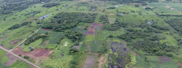
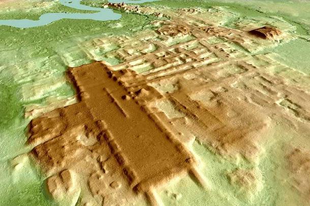
Mexico’s Aguada Fénix archaeological site as seen from the air reveals little about Olmec and Maya similarities and imitations in ritual architectural design. It took a LiDAR survey, see image below, to reveal what was really there! (francetvinfo.fr / CC BY-SA 4.0 )
Exploring the Deep Olmec and Maya Connection
In 2020, the same team of researchers, led by University of Arizona anthropologist Takeshi Inomata, discovered the oldest and largest Maya ceremonial site ever found, which they dubbed Aguada Fénix .
This long, flattened, rectangular mound is almost one mile (1.6 kilometers) in length and is raised between 33 and 50 feet (10 and 15 meters) off the ground. It features 20 much smaller platforms built around its perimeter, and from the air resembles a long banquet or pool table. Aguada Fénix was constructed between 1,000 BC and 800 BC, in the pre-classical stage of the Maya civilization .
Many of the religious complexes discovered in Maya territory during the latest survey greatly resemble Aguada Fénix in shape and design. Most significantly, all of these sites seem to mimic a newly discovered rectangular ceremonial complex found at San Lorenzo , the oldest and one of the most important Olmec population centers . It is here that the famed colossal heads that depict Olmec rulers were discovered, along with other signs of a complex culture that created the first great Mesoamerican civilization in the second millennium BC.
The newly discovered ceremonial monument at San Lorenzo is 3,300 (1,000 meters) long and 900 feet (275 meters) wide, with 20 raised platforms arranged around its edges. It was clearly a gathering place of some sort, and important religious ceremonies or rituals were almost assuredly held there, the researchers believe.
The monument’s resemblance to Aguada Fénix and the other freshly detected Maya sites is unmistakable. Yet it was constructed two or three centuries earlier, which has led the University of Arizona researchers to speculate that the San Lorenzo site may have acted as a template for Maya ceremonial site construction.
“People always thought San Lorenzo was very unique and different from what came later in terms of site arrangement,” Inomata said, in a University of Arizona press release announcing his research team’s discoveries. “But now we show that San Lorenzo is very similar to Aguada Fénix – it has a rectangular plaza flanked by edge platforms. Those features become very clear in LiDAR and are also found at Aguada Fénix, which was built a little bit later. This tells us that San Lorenzo is very important for the beginning of some of these ideas that were later used by the Maya .”

A LiDAR view of the same landscape shown in the previous picture at the Aguada Fénix archaeological site that reveals the Maya building complex and its similarities to Olmec design. (Alfonsobouchot / CC BY-SA 4.0 )
According to Inomata and his colleagues, the Maya would have been imitating Olmec building practices because the two cultures shared elements of the same metaphysical belief system.
“City plans symbolizing cosmologies have long been recognized as a defining element of Mesoamerican civilizations,” they noted in their Nature Human Behavior paper.
After analyzing the orientations of the ancient Olmec and Maya sites carefully, the researchers discovered that most are aligned with the sunrise on certain dates. These choices appear to be related specifically to zenith passage day, when the sun at its highest point is aligned directly overhead the ground level observer, at a 90-degree angle to the horizon.
Zenith passage day varies by latitude and occurs on May 10 in the region surveyed. The researchers found that many of the Maya and Olmec sites were oriented to face the sunrise exactly 40, 60, 80, or 100 days before that date. Mesoamerican calendars are based on the number 20, which would explain why such orientations were chosen. It would also explain why there were 20 small platforms placed around the edges of the larger ceremonial platforms built at San Lorenzo, Aguada Fénix, and other newly discovered Maya sites.
“This means that they were representing cosmological ideas through these ceremonial spaces,” Inomata declared. “In this space, people gathered according to this ceremonial calendar.”
Zenith passage day was important to Mesoamerican civilizations because it represented the arrival of both maize planting season and the rainy season that would help new crops grow tall and strong. But the coordination of monumental structures with important astronomical alignments was a common practice among virtually all the ancient cultures in the Americas, including the Olmecs, the Maya, the Aztecs, and the Hopewell culture of North America.
One mystery archaeologists and ancient historians have pondered over the years is how much influence Olmec practices and customs had on their Maya neighbors. If San Lorenzo was indeed an inspiration for the Maya ceremonial building practices, it would seem the influence was quite strong, at least in this one vitally important area.

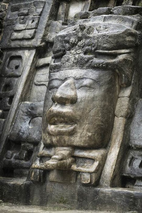
This Olmec style stone face on the Lamanai Mayan temple in Belize is almost identical to the later Maya temple shown in the main image at the top of this article. ( Wollwerth Imagery / Adobe Stock)
Following the LiDAR
This extraordinary new study has enlightened scholars about the deep connections that may have developed between the Olmec and Maya cultures, which existed side-by-side in Mesoamerica for approximately 1,500 years. This research was only possible because of the LiDAR remote-sensing system, which has been a boon to archaeologists seeking to study ruins and artifacts on a broader and more inclusive scale.
LiDAR, which stands for “light detection and ranging,” is an aerial sensing technology that uses pulsed laser reflections to create precise three-dimensional images of the earth’s surface. This methodology can be used to spot ruins that would otherwise be hidden by trees, vegetation, or shallow layers of earth.
“The advantage of LiDAR is that it provides a three-dimensional, birds-eye view of the landscape and modifications to it made by humans – ancient and modern – in the form of building, transportation, agricultural and water control infrastructure,” study participant Juan Carlos Fernandez-Diaz, who works at the University of Houston’s National Center of Airborne Laser Mapping, told Reuters .
In addition to producing superior imagery, LiDAR technology also gives archaeologists the ability to explore large sections of the land from the air. The process is swift and efficient, making studies like this new one far easier to complete.
This ambitious research project fully leveraged the capabilities of LiDAR, more so than any other study that has been carried out in the area so far. It will likely be used again to explore these regions, as archaeologists and historians continue to search for more information about the great pre-Columbian civilizations that once flourished in ancient Mesoamerica.
Top image: Olmec and Maya architecture have more than a few things in common as has been recently revealed by a massive LiDAR survey project in southern Mexico. The Olmecs came first but the Mayas copied their approach to ritual architecture. This image shows a Maya building in the Lamanai archaeological reserve in Belize. Source: vadim.nefedov / Adobe Stock
By Nathan Falde
Related posts:
Views: 0
 RSS Feed


 October 27th, 2021
  Awake Goy
  Posted in
  Tags:
Tags: 


